GPR & Utilities Surveys
Belowground Utility and Drainage Surveys
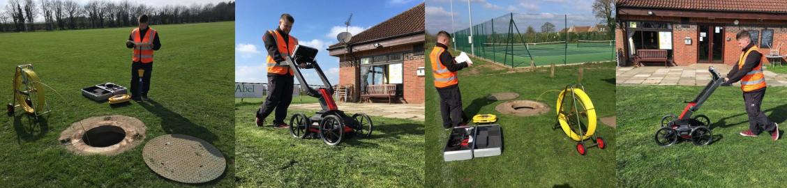
Following extensive training we are pleased to be able to offer non-intrusive belowground surveys, including utility surveys to PAS 128 standard using Ground Penetrating Radar (GPR) technology, providing real-time insight into the shallow subsurface, locating utilities or ground anomalies.
GPR equipment uses radar pulses to visualise below-ground matter which is a quick and unobtrusive method of initially discovering various underground features, including both private and utility services’ cables and pipes.
By combining the GPR equipment with our CAT Scanner, we can help to identify the service routes and our team can mark them up on site and/or indicate them on an AutoCAD drawing to give clients a basic guidance when it comes to invasive works, from trial holes to industrial scale developments.
Larger GPR surveys, using post processing techniques, can be used with larger subsurface targets or where greater depth penetration is required. Plandescil will collect GPR and locational data on-site, then process data according to the target or survey requirements.
Post-processing can provide the client with more in-depth data, removing background noise and amplifying target signals, we can ‘tune into’ the signal traces we are interested in.
After survey data has been manipulated with post-processing techniques, Plandescil can provide GPR scans overlaid onto maps or in AutoCAD format with accurate location reference and insightful notes. GPR location data can also be given in ASCII format.
As well as locating utility services, using GPR technology we are also able to identify other belowground matter and disturbances such as subsurface voids, water, or geological layers; in the past we have used our GPR to locate the ruins of an old castle and unexploded ordnance.
It is imperative to locate belowground apparatus before embarking on any construction works and we advise clients to get this work undertaken before considering site layout plans to ensure the proposal is feasible.
We are able to expand on utility surveys with our drainage CCTV camera which allows us to undertake condition surveys of drainage systems and identify leaks or obstructions. This can be useful for domestic clients who are having issues with their septic tanks and treatment plants or commercial clients who need to get their drainage signed-off by the Environment Agency.
We have used our GPR to successfully examine ground formations in a range of small to large projects. For example, a sinking back garden caused by drainage washout was creating void space underneath a patio. Plandescil used Ground Penetrating Radar to identify the cause of the problem, and the extent of the voids. Giving instruction for contractors to be able to backfill the areas and prevent future depression.
Larger examples of survey projects include determining the depth and thickness of a large scale geosynthetic clay liner. Plandescil scanned the ground using widely spaced out transects to cover a large area, whilst collecting GPS data to provide locational reference. Data was then processed and analysed to locate the target layer, and average values of the depth and thickness of the layer could be given across the site.
