Surveying Land & Buildings
Reliable survey information is an essential initial phase for any land, engineering or architectural project. Using Real Time GPS instruments combined with Robotic and Reflectorless EDM survey technology we are fully equipped and committed to provide a rapid, prompt and accurate service.
Directed by our Chartered Senior Surveyor, with over 25 years of Surveying and Civil Engineering experience, our professionally qualified and experienced survey team is able to understand project requirements, enabling pertinent information to be recorded or set out on site. Our qualified and experienced Civil Engineering survey team use their engineering eye when undertaking surveys to ensure that they provide the information likely to be required if future development occurs on the site.
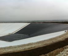
Using industry leading survey processing and ground modelling software, we are able to create digital terrain models to accurately record, design and calculate the earthworks for your project. Our highly featured coloured drawings can easily be read by the layman and professional. Works include irrigation reservoirs and digestate lagoon design, complex cut and fill analysis and quantifying stockpile volumes.
Calling on a diverse range of surveying experience from individual building plots, town centre regeneration projects, residential and commercial developments, country estates, highways, racing circuits, schools, churches, quarries and land fill, no job is too small or complex for our surveying team to tackle.
Working with a varied client base from contractors, developers, local authorities and private individuals, our surveys can be passed in-house to our multi-disciplined design team providing a rapid follow-on service to meet project engineering needs.
Surveying Land & Buildings Services:
- Geomatic/topographical site surveys
- Buildings, road and earthworks setting out
- 3D digital terrain modelling
- Volumetric analysis
- Site area computations
- Flood risk surveys using GPS active network
- Measured building floor plans and elevation surveys
- As built record surveys
- Land transfer plans to land registry requirements
- Assistance in land boundary disputes
- Sewerage network surveys
- Deterioration monitoring
- Preparation of asset plans including utilities
- Ground Penetrating Radar (GPR) Surveys
- Utilities Surveys
- CCTV drainage surveys
- Laserscanner surveys & modelling
- Drone services including photogrammetry